|
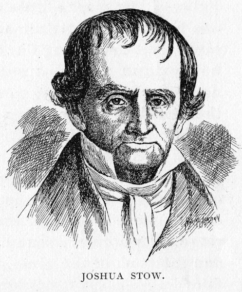
CHAPTER II LAYING THE FOUNDATIONS When the order was given to move toward the West, several of the party were placed in charge of the horses and cattle, and sent overland to Buffalo. Others proceeded in boats by way of the Mohawk River. On reaching Fort Stanwix, now known as Rome, N. Y., they transferred across the portage to Wood Creek, passed down to Oneida Lake, across that body and its outlets, and so down the Oswego River to Lake Ontario. They sailed along the coast of the lake to the mouth of the Niagara River and along the same to Queenstown, where they crossed another portage and reached Chippewa, from whence they passed up the Niagara and Lake Erie to Buffalo, where they met the detachment which had come overland. Naturally, many hardships were encountered upon the way, for it was no light undertaking to conduct an expedition of this size and character across many miles of new and unbroken country. Little is said of these, however, by the hardy men upon whom these labors fell. One of the surveyors, John Milton Holley, industriously kept a journal in which a number of incidents of a minor nature are recorded. Under date of May 31st, he says: "Stow (the commissary) and Stoddard (one of the surveyors) came from Sodus, on Lake Ontario, with information that three boats were cast away, but no lives or property lost; in consequence of which we left Canandaiqua the 31st of May for Gerundicut (Irondequoit), slept the first night at Howe�s in Boughton town. "June 1st. Went to the landing to see our boat, but as it had not arrived, Porter, Stow and myself embarked On Dunbar�s boat, to go to the great lake to meet our boat, but as luck would have it, we went in the boat about half a mile to the landing, unloaded, and Porter with four hands returned to Little Sodus, to give relief to those who were cast away, and Stow and myself with our hands encamped on the Gerundicut. Built a bark hut, and the men lodged in it the first night. Stow and myself lodged on the floor at Dunbar�s.
"June 3rd, Gen. Cleaveland at evening arrived at Canandaiqua and gave us information that the boats had gone from Whitestown to Fort Stanwix, and Mr. Stow got a letter from the British Minister, or charge des� affaires, to the commanding officer at Fort Oswego, requesting permission for our boats to pass unmolested. This information, together with the favorable prospect of wind and weather at that time, gave us great hopes that the stores would get on safely and rapidly, but on Saturday morning there sprang up in the northwest a storm, and blew most violently on the shore of the lake. This proved fatal to one of the boats, and damaged another very much though we went a little forward to a safe harbor, and built several fires on the bank of the lake, as a beacon to those coming on. After the disaster had happened, the boat that was safe went on the Gerundicut with a load, and left the other three, including the one that was stove, at Little Sodus encamped near the lake. Among the passengers were two families, one of the women with a little child. . . .Started from Canandaiqua, and arrived on the morning of the 4th. All these misfortunes happened in consequence of not having liberty to pass the fort at Oswe- go.26 Such are the effects of allowing the British government to exist on the continent of America." On June 17, the journal records the fact that "at evening we got to Skinner�s tavern, at Buffalo creek." On the 18th: "Porter and myself went on the creek in a bark canoe, a-fishing, and caught only three little ones." On Sunday, June 19th: "Left Buffalo in Winney�s boat, for Chippewa, had a fair wind down, and arrived about one o�clock at Chippewa, dined at Fanning�s, found our good were not at the Gore, in Chippewa, and was obliged to go to Queenstown after them, and as I could not get a horse was obliged to walk. I got to Queenstown before night, and lodged at Caleb Ingersoll�s; next morning set out for Buffalo. On the way I stopped to look at Niagara Falls. That river a little above Fort Slusher, is two and one half miles wide. Soon after this the water is very rapid, and continuing on, is hurried with amazing impetuosity down the most stupendous precipice perhaps in nature. There is a fog continually arising, occasioned by the tumbling of the water, which, in a clear morning, is seen from Lake Erie, at the distance of thirty or forty miles, as is the noise also heard. As the hands were very dilatory in leaving Chippewa, we were obliged to encamp on the great island in the river. We struck a fire and cooked some squirrels and pigeons, and a young partridge. I slept very sound all night, between a large log and the bank of the river. The next day arrived at Buffalo." It was at the point last named that General Cleaveland was permitted to fulfill, in a measure, one of the duties with which he had been charged by those under whose authority he was acting. Although various treaties had been made with the Indians, by which it was supposed they had given up all claims to the lands east of the Cuyahoga, the party were met at Buffalo by a claim which, if not adjusted, would be certain to create trouble in the present, and danger to the near settlements of the future. The General was confronted by representatives o the Mohawk and Seneca Indians, headed by the famous Red Jacket, and Joseph Brant otherwise known to fame by his Indian name of Thayendanega, who were determined to use force if necessary, to oppose the further progress of the expedition toward the West. In the skill and address with which he met this danger and averted it, the General showed himself a diplomat as well as a soldier. A conference, or council, was arranged. "At two o�clock this afternoon." we learn from the record of Surveyor Holley, "the council fire with the Six Nations was uncovered, and at evening was again covered until morning, when it was opened again, and after some considerable delay, Captain Brant gave General Cleaveland a speech in writing. "The chiefs, after this, were determined to get drunk. No more business was done this day. In the evening the Indians had one of their old ceremonial dances, where one gets up and walks up and down between them, singing something, and those who sit around keep tune by grunting. Next morning, which was the 23rd, after several speeches back and forth, from Red Jacket to General Cleaveland, Captain Chapin, Brant, etc., General Cleaveland answered Brant�s speech. In short, the business was concluded in this way. General Cleaveland offered Brant one thousand dollars as a present. Brant, in answer, told General Cleaveland that their minds were easily satisfied, but that they thought his offer was not enough, and added this to it, that if he would use his influence with the United States to procure an annuity of five hundred dollars par, and if this should fail that the Connecticut Land Company should, in a reasonable time, make an additional present of one thousand five hundred dollars, which was agreed to. The Mohawks are to give one hundred dollars to the Senecas, and Cleaveland gave two beef cattle and whisky to make a feast for them. In return for the payments above promised, and the agreement to intercede with the government, it was guaranteed by the chiefs that the settlers upon the Reserve should not be molested; and this agreement, so far as they were concerned, was faithfully carried out. Our recording surveyor pauses for a moment in his narration of events to relate a side incident which casts a light upon the shrewd philosophy of one of these children of the forests: "Farmer�s Brother, Red Jacket and Little Billy and Green Grass Hopper dined with the commissioners. In the course of conversation, Red Jacket gave his sentiments upon religion, which were to this purpose: �You white people make a great parade about religion; you say you have a book of laws and rules which was given you by the Great Spirit, but is this true? Was it written by his own hand and given to you? No,� says he, �it was written by your own people. They do it to deceive you. Their whole wishes center here (pointing to his pocket); all they want is the money. (It happened there was a priest in the room at the same time who heard him.) He says white people tell them they wish to come and live among them as brothers and learn them agriculture. So they bring on implements of husbandry and presents, tell them good stories, and all appears honest. But when they are gone all appears as a dream. Our land is taken from us, and still we don� know how to farm it�" This seems, in some respects, a very shrewd presentation of the vexed "Indian question" at an early day. These formidable powers having been conciliated, the expedition again moved westward, in two divisions, as before; one by land and the other by Lake Erie. On the 4th day of July, at 6 p. m., they reached the mouth of Conneaut Creek. They were at last upon the Reserve, and as their arrival was upon a date made memorable by the stirring Declaration of but twenty years before, these patriotic sons of Connecticut naturally celebrated as seemed most fitting, and with such means of rejoicing as were at command. There have been many celebrations of our nation�s natal day upon the Western Reserve since its opening to civilization one hundred years ago, but there have perhaps been none more hearty and patriotic27 than this first one, held in sight of the beautiful Erie, and among the woods of Conneaut. We can see this little and of fifty, drawn the more closely together because they were so few in number, and so far from home and kindred, uniting with each other in song, in toast and hearty expressions of good will. The day had been serene, the foliage about them was in its best shades of summer green, ant little creek wound thread-like between its banks, and out beyond the water of blue Erie sparkled in the setting sun.28 There was much lacking of the needs and devices of civilization, but they were hardy men, well used to rough service, and to whom there were but a half dozen essentials of life just then�food, drink, clothing, shelter and ammunition. The new flag of the new nation was flung to the breeze. Tables were arranged and baked beans and pork showed well I evidence. "We gave three cheers," says Cleaveland, "and christened the place Port Independence." Salutes of musketry, under command of Captain Joseph Tinker, were fired�one for each State in the Union, and one for New Connecticut; and toasts proposed, of which the chronicler last quoted gives a list: 1st. "The President of the United States." It is with no small regret that we fail to report the speeches made upon that occasion�for speech there must have been, set or otherwise, among these patriotic sons of New England. No record of these was made, as Surveyor Holley and his associates were more interested in recording township boundaries and noting variations of the compass, than the Fourth of July outbursts of a little band of strangers in the new country.29 When General Cleaveland tells us that the celebration "closed with three cheers; drank several pails of grog, supped, and retired in good order," we have no right to assume that a bibulous set of individuals had been sent upon this important mission. They drank no more and no less than was the custom of their day, and of the communities in which they lived. This was, beyond doubt, the first celebration of Independence Day upon the Reserve. On the day following, the actual work of the expedition was commenced. General Cleaveland wrote to the directors of the company, reporting progress; and two boats under command of Captain Tinker were sent to Fort Erie to bring on a portion of the stores that had been temporarily left there. The men were set to work at cutting timber, and erecting a large log structure for temporary accommodation, which was named "Castle Stow," in honor of Commissary Joshua Stow. It was constructed of unhewn logs, roofed with a combination thatch of brush, wild grasses and sod. We are told by Harvey Rice that "the style of architecture was entirely unique, and its uncouth appearance such as to provoke the laughter of the builders and the ridicule of the Indians." These red natives of the soil were moved by yet another impulse that had a serious side, as they saw these preparations for permanent occupation. They could not understand just what was contemplated, but saw that something was on foot that boded no good for their continued possession of the soil. An explanation was demanded. The manner in which the demand was made is thus related by General Cleaveland himself: "Received a message from the Paqua chief of the Masasagoes, residing in Conneaut, that they wished a council held that day. I prepared to meet them and after they were all seated, took my seat in the middle. Cato, son of Paqua, was the orator; Paqua dictated. They opened the council by smoking the pipe of peace and friendship. The orator then rose and addressed me in the language of Indian flattery, �Then The Great Spirit for preserving and bringing me there. Thank The Great Spirit for giving a pleasant day,� and then requested to know our claim to the land, as they had friends who resided on the land, and others at a distance who would come there. They wanted to know what I would do with them. I replied, informing them of our title and what I had said to the Six Nations, and also assured them that they should not be disturbed in their possessions; we would treat them and their friends as brothers. They then presented me with the pipe of friendship and peace, a curious one, indeed. I returned a chain of wampum, silver trinkets, and other presents, and whisky, to the amount of about twenty-five dollars. They also said they were poor; and as I had expressed, hoped we should be friendly and continue to be liberal. I told them I acted for others as well as for myself, and to be liberal of others� property was no evidence of true friendship; those people I represented lived by industry, and to give away their property lavishly to those who lived in indolence and by begging, would be no deed of charity. As long as they were industrious and conducted themselves well, I would do such benevolent acts to them as would be judged right and would do them the most good; cautioned them against indolence and drunkenness. This not only closed the business, but checked their begging for more whisky." After this second council with the Indians, the General addressed himself squarely to the work in hand, which was to lay out a part of the Reserve into townships five miles square, and the townships into one hundred acre lots. The surveyors were assigned to their respective labors, and set out upon the fulfillment thereof. It is our immediate mission to follow only those who proceeded westward toward the Cuyahoga. In a couple of weeks Cleaveland selected certain of his staff, and with them proceeded in an open boat along the shore of Erie, until he reached a stream that he concluded was the Cuyahoga, which was his objective point. He proceeded up it, as rapidly as the sandbanks and fallen timber would permit, and soon found that he had made the mistake of entering a stream not laid down upon his map. It is declared by some authorities that in commemoration of this error, and of his consequent disappointment over delay, he called the stream "the Chagrin"�an appellation which it retains to-day.30 Retracing their way to the lake, the little party sailed and rowed still westward, and on the morning of July 22nd, in the year 1796, passed into the Cuyahoga, and stood upon its eastern bank near the entrance to the lake. No formal ceremony marked this entrance of civilization, in the persons of Moses Cleaveland and his men, upon the spot where within the coming century a great city was to be reared. As a matter of fact, the landing was very commonplace in its character. "They reached the veritable Cuyahoga," says Mr. Rice,31with that dry humor that was so telling and characteristic, "and after advancing a short distance in its channel, attempted to land, but in their efforts to do so ran their boat into the marshy growth of wild vegetation which skirted the easterly bank of the river, and stranded her. Here �Moses,� like his ancient name�s sake, found himself cradled in the bulrushes. This occurred near the foot of Union Lane, which was at that time the termination of an Indian trail. The party soon succeeded in effecting a safe landing. They then ascended the precipitous bluff, which overlooked the valley of the river, and were astonished to find a broad and beautiful plain of woodland stretching far away to the east, west and south of them, and lying at an elevation of some eighty feet above the dark blue waters of Lake Erie. The entire party became enamored of the scene." "A young growth of oaks with low bushy tops covered the ground," adds Col. Whittlesey,32 in further description of the scene. "Beneath them were thrifty bushes, rooted in a lean but dry and pleasant soil, favorable to the object in view. A smooth and even field sloped gently toward the lake, whose blue waters could be seen extending to the horizon." Those who in a mental vision can reconstruct the scene, with the lake, and river, and wooded land; with no sign of habitation or the work of man; with the Cuyahoga at their feet, and the hills rising above it; with no rise of smoke in all the landscape; green leaves above them, and verdant carpets beneath their feet; a fair sky shining over it all, can well understand how the beauty and fitness of the place for the purposes they had in mind were impressed upon the visitors, and that then and there was born the fruitful thought out of which this fair and prosperous Forest City has grown. General Cleaveland decided�not just then, but a little later�that the main town of such portion of the Reserve as lay within his jurisdiction should be built here. His prophetic eye was true in its investigation of the future, and although his little city was for a time humiliated by being described as "six miles from Newburgh," where the grist-mill was�all later developments have shown that in no better place could the metropolis of the Reserve have been built. The 5th of August found the General back again at Port Independence (Conneaut Creek), where he made a lengthy report to the home company,33 giving his views upon various things in a plain and by no means optimistic manner. After touching upon affairs in the eastern section of the Reserve, he says: "The Cuyahoga is navigable for sloops about eight miles as the river runs, and for boats to the portage, if the immense quantity of trees drove down and lodged are cleared out. The land excellent, the water clear and lively current, and streams and springs falling into all three rivers.34 We went in a Schenectady boat, the �Cuyahoga,� about twenty-five miles to the old Moravian Indian town, and I imagine on a meridian line, not more than twelve or fifteen miles. Here the bottoms widen, and as I am informed, increase in width, and if possible in quality, I believe we could have proceeded farther up the river, but found the time allotted, and the provision inadequate to perform the whole route. At this place we found a stream, that empties into the river, which will make a good mill seat. The lands on the lake shore, in some places low, here and there a small cranberry pond, not of any great extent, nor discovered low drowned lands of any bigness for twenty or thirty miles on the lake shore. On the east of the Cuyahoga are clay banks from twenty to forty feet high, on the tope the land level, covered with chestnut, oak, walnut, ash, and some sugar maple. There are but few hemlocks, and those only on a swamp, pond or lake, and in the immense quantity of flood wood lodged on the lakes and rivers, I rarely found any of that wood. The shore west of the mouth of the Cuyahoga is a steep bank for ten miles, the quality of the soil I know not, but from the growth and kind of timber, these present no unfavorable aspect. I should with great pleasure, readily comply with what I suppose you have heretofore expected that I should leave this country about this time. I have not as yet been interrupted in a constant attention to business, more than I could have imagine or would have voluntarily entered into, and I see no prospect of its lessening at present. Those who are meanly envying the compensation and sitting at their ease and see their prosperity increasing at the loss of health, ease, and comfort of others, I wish might experience the hardships for one month; if not then satisfied their grumbling would give me no pain. I apprehend the stagnant waters in Lake Erie (except to the westward) must be of small dimensions. The interior lakes and ponds, though not included in Livingston�s commutation, are, I expect, few and small, unless the land bears more to the northwest, after it passes the Cuyahoga than it does this side, the surplus will not be consequential. It is impossible at present to determine on the place for the capital. More information of the extent of the ceded lands and ye traverse of the lakes and rivers wanted, this will cause delay and require examination. I believe it will be on the Cuyahoga it must command the greatest communication, either by land or water of any other place on the purchase or on any ceded lands west of the head of the Mohawk. I expect soon to leave this for the westward, and shall make my residence there until I am ready to return to Connecticut. The men are remarkably healthy, though without sauce or vegetables, and in good spirits. I hope they will continue so." Facing Page
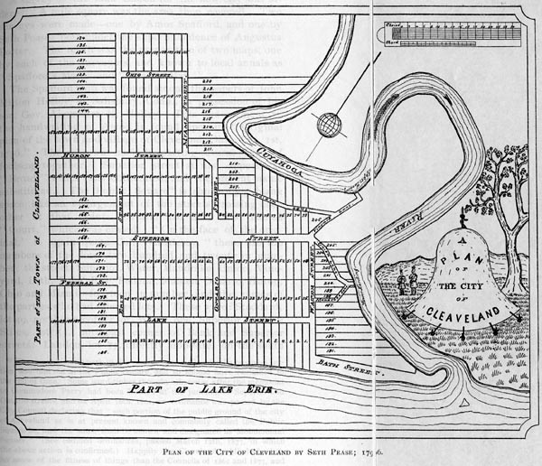
A survey of the land chosen for the new city was ordered. A mile square was the area then covered. Two surveys were made�one by Amos Spafford, and one by Seth Pease; both under the superintendence of Augustus Porter. The result was the preparation of two maps, one by each of the surveyors, and known to local annals as "Spafford�s May" and "Pease�s Map." The Spafford map was found among the papers of John Milton Holley, at Salisbury, Conn., in possession of his son, Gov. Alexander H. Holley. This endorsement, in the handwriting of Amos, is found upon it: "Original plan of the town and village of Cleveland, Ohio, Oct. 1st, 1796." The map was made by pasting several sheets of foolscap together. Superior street at first appears as "Broad." which was obliterated, and the present name substituted. The Public Square35 is shown by a blank space, like an enlargement to the streets crossing each other at that point; Ontario had been first named "Court," which was erased. "On the face of the original," to again quote Col. Whittlesey, "there are the numbers of the lots�two hundred and twenty in number; the streets Superior, Water, Mandrake, Union, Vineyard, Bath, Lake, Erie, Federal, Maiden, Ontario, Huron, Ohio and Miami�fourteen in number, and the names of the parties who had selected lots. These were: Stoddard, lot 49, northeast corner of Water and Superior streets; Stiles, lot 53, northeast corner of Bank and Superior streets; Landon, lot 77, directly opposite, on the south side of Superior street; Baum, lot 65, sixteen rods east of the Public Square; Shepherd,, lot 69, the Chapman, lot 72, all o the north side of the same street. �Pease�s Hotel,� as they styled the surveyor�s cabin, is placed on the line between lots 202 and 203, between Union street and the river. Northwest of it, about ten rods, on lot 201, their store house is laid down. Vineyard, Union and Mandrake streets were laid out to secure access to the upper and lower landings on the river. Bath street provided a way of reaching the lake shore and the mouth of the river." Even a city as yet only upon paper must have a name and the question as to a title for the capital of New Connecticut, which had probably been under consideration for some time, now demanded settlement. The name "Cuyahoga" had been proposed, and there are letters in existence showing that it was in use to designate the present location of Cleveland. General Cleaveland confessed himself unequal to the task, and, we are told, "upon the earnest suggestion and advice of the surveyors," was persuaded to make use of his own name, and thus "Cleaveland, New Connecticut," took its place upon the yet imperfect and uncertain maps of the Great West. Just when and by whom the letter "a" was first dropped from the name has never been definitely determined. The early records vary in their custom, some following the spelling adopted by the city�s founder, and others the more convenient mode that in later days became universal by general consent. In Judge Griswold�s admirable paper, elsewhere quoted at some length, on the corporate birth and growth of Cleveland, we find this statement: "There was first made (in these early surveys) a rough field note on which these lots, streets and grounds were marked and laid out, but a more perfect and complete map was made by Seth Pease and finished before the 1st of October of that year (1796). On this old field map, there was written in fair hand, as well to perpetuate the General�s memory, as the event itself, �The City of Cleveland.� In the spelling, the letter �a� in the first syllable always used by the General himself was omitted."36 There may be found in the office of the city clerk of Cleveland a small and dingy book, with leaves yellowed by time, edges worn away, and the leather cover black and mouldy with decay It contains the records of the township of Cleveland, commencing with 1803, and in this the name is almost altogether spelled with the "a"," until about 1832 or 1833. When the "Cleaveland Herald" came into existence, in 1819, it was loyal to the General, in that it used his name without omitting a letter, and so continued up to 1832, when there is a break in the files at the rooms of the Western Reserve Historical Society from April 12th to June 8th, 1833, on which latter date it is found without the added letter. One of the many and varied statements made upon the subject is found in the following, from the pen of Hon. A. J. Williams:37 "Some years before his death, Gen. A. S. Sanford, an old settler and printer in Cleveland, and one of our most valued citizens, related to me the circumstances that occasion d the dropping of the first �a� in the original name of our city, �Cleaveland.� The letter was not omitted in the �Herald� until 1832, but prior to that date, the �Cleaveland Advertiser� was published. General Sanford said the paper for the �Advertiser� was purchased from the paper mill at Cuyahoga Falls; that for one issue therof the paper received was too small for the heading �Cleaveland Advertiser,� and that to use the same, it became necessary to drop from the heading the �a� from the name �Cleaveland.� This was done and from about that time the name of the village and of our city became Cleveland."38 A more plausible theory, and one that bears a closer mark of genuineness, is stated as follows: That when the "Herald" was being printed, a "sheep�s-foot,"�something any old printer will know all about�struck the letter "A" in the heading, and so battered it that it was useless. As new type could not be had this side of Buffalo, or perhaps New York or Philadelphia, the damaged "A" was left out, and never again found its place in the heading. J. A. Howells, an Ashtabula editor, says that when his father was clerk of the Ohio Senate about 1856, one of the members of the legislature, who had been a printer on the "Herald," made the above statement as one of fact, and that J. A. Harris, for years editor of that newspaper, confirmed it. Mr. Howells adds, in answer to the Sanford theory, that he compared issues of the "Herald," both before and after the dripping of the "A" and found there had been no change�that the paper was of the same size right along.38a In returning to the original surveys, we can do no bet- Facing page
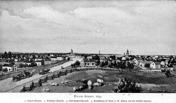
ter than use a copious extract from a monograph.39 Prepared for presentation before the Early Settlers� Association, by an eminent member of the Cleveland Bar, Judge Seneca O. Griswold. He said: "In the old field map, the name of Superior street was first written �Broad,� Ontario� Court,� and Miami �Deer;� but these words were crossed out with ink, and the same names written as given in Pease�s map and minutes. In Spafford�s map, �Maiden Lane,� which led from Ontario street along the side of the hill to Vineyard Lane, was omitted, and the same was never worked or used. Spafford also laid out Superior Lane, which was not on the Pease map, which has since been widened, and become that portion of Superior street from Water down the hill to the river. Bath street is not described in the Pease minutes, but is laid out on the map, and is referred to in the minutes, and the boundaries and extent appear on the map. The Square also is not described in the Pease minutes, but is referred to in the description of Ontario and Superior streets, and is marked and laid out on the map. In Safford�s minutes the Square is thus described: �The Square is laid out at the intersection of Superior street and Ontario street, and contains ten acres. The center of the junction of the two roads is the exact center of the Square.� These surveys, the laying out of the lots bounding on the Square, their adoption by the land company, the subsequent sale by said company of the surrounding lots abutting upon it, make the Square as much land devoted to public use as the streets themselves, and forever forbids the same being given up to private uses. The easterly line of the city was the east line of one tier of lots, beyond Erie street, coinciding with the present line of Canfield street. The east line began at the lake and extended southerly one tier of lots south of Ohio street. The line then ran to the river, down to the river, skipping the lower bend of the river to Vineyard Lane, thence along Vineyard Lane to the junction of Water with Superior street, thence to the river, thence down the river to its mouth. Superior street, as the survey shows, was 132 feet in width, the other streets 99 feet. It is hardly possible to fully appreciate the sagacity and foresight of this leader of the surveying party. With full consciousness of what would arise in its future growth, he knew the city would have a suburban population, and he directed the immediate outlying land to be laid off in ten-acre lots, and the rest of the township into 100-acre lots, instead of the larger tracts into which the other townships were divided. The next year the ten-acre lots were surveyed and laid out. They extended on the east to the line of what is now Willson avenue, and on the south to the top of the brow of the ravine formed by Kingsbury Run, and extended westwardly to the river bank. Owing to the peculiar topography of the place, some of the two-acre lots had more and others less than the named quantity of land, and the same occurred in the survey and laying out of the ten-acre lots. The flats were not surveyed off into lots, and there was an unsurveyed strip between the west line of the ten-acre lots and the river, above and below the mouth of the Kingsbury Run, running south to a point west of hundred-acre lot 278. Three streets were laid out through the ten-acre lots, each 99 feet in width to correspond with the city streets, called the South, Middle and North Highway. The southerly one becoming Kinsman street, and Middle, Euclid street at its intersection with Huron; the southerly one received its name from the fact that Kinsman, the east township of the seventh line of townships, was at a very early period distinguished for its wealth and population. The Middle was called Euclid because that was the name of the next township east. The North Highway was a continuation of Federal street, but changed to St. Clair, after the name of the territorial governor, whose name, in the minds of his admirers, was a synonym of Federal" As yet no civil township had been organized in this por- tion of the present Cuyahoga County, the territory upon the east side of the river being a part of Washington County, of the Northwest Territory. It was a question whether legal jurisdiction there was held by the territorial authorities or by the Connecticut Land Company. The section west of the Cuyahoga River nominally belonged to the county of Wayne, and, although the pre-emption rights had been purchased by the land company, the claims of the Indians had not been satisfied, and they were still in undisputed possession. The survey township, in which Cleveland was situated, was one of the six which had been selected to be sold for the direct benefit of the company as an organization, and not divided among the stockholders, as was the case with so many of the other towns of the Reserve. The plan, as proposed, was to first sell only a quarter of the townships; and a proposition was submitted by Augustus Porter, the chief of the surveyors, as to the manner in which such sale was to be carried out; This plan has been described in full: "In the first place, city lots Number 58 to 63 inclusive, and 81 to 87 inclusive, comprising all the lots bordering on the Public Square, and one more, were to be reserved for public purposes, as were also �the point of land west of the town� (which we take to be the low peninsula southwest of the viaduct), and some other portions of the flats if thought advisable. Then Mr. Porter proposed to begin with lot number one, and offer for sale every fourth number in succession throughout the towns, on these terms. Each person who would engage to become an actual settler in 1797 might purchase one town lot, one ten or twenty-acre lot, and one hundred-acre lot, or as much less as he might choose; settlement, however, to be imperative in every case. The price of town lots was to be fifty dollars; that of ten-acre lots three dollars per acre; that of twenty-acre lots two dollars per acre; and that of hundred-acre lots a dollar and a half per acre. The town lots were to be paid for in ready cash; for the larger tracts twenty per cent, was to be paid down, and the rest in three annual installments with annual interest. It will be seen that even at that time the projectors of Cleveland had a pretty good opinion of its future; valuing the almost unbroken forest which constituted the city at twenty-five dollars per acre in cash, while equally good land outside its limits was to be sold for from three dollars down to a dollar and a half per acre, with three year� credit.40 Not many incidents have been placed upon record of the life and labors of the little party who, during the summer and early fall of 1796, were industriously engaged in laying the foundations of the Forest City. It was by no means a life of ease and pleasure�the surveyors, as Colonel Whittlesey says, "were not always sure of supper at night, nor of their drink of New England rum, which constituted an important part of their rations; their well provided clothing began to show rents, from so much clambering over logs and through thickets; their shoes gave out rapidly, as they were incessantly on foot, and were where no cobblers could be found to repair them; every day was one of toil, and frequently of discomfort. The woods, and particularly the swamps, were filled with ravenous mosquitoes, which were never idle, day or night; in rainy weather the bushes were wet, and in clear weather the heat was oppressive. It was not always practicable to have provisions promptly delivered to the surveying parties, so that their work could go on without interruption." Affairs had reached a rather unpleasant strait by the later days of September, when the surveyors and their assistants, who had collected at headquarters, found themselves out of meat, with but little flour, a couple of cheese, and some chocolate. As they were figuring on ways and means, some sharp eye saw a bear swimming across the river. There was a rush for guns and canoes, and in the midst of the excitement the bear paused, turned about, landed upon the western shore, and carried the anticipated fresh meat of the hungry men into the woods. The success attending a raid upon the reptile kingdom was more gratifying, as we find in Holley�s Journal the entry" "Munson caught a rattlesnake, which we boiled and ate." Later in the day a party with provisions and cattle came over from Conneaut, and were received with an unquestioned welcome. A readjustment of the arrangement between the Connecticut Land Company and the surveyors� staff was one of the outcomes of the hardships of the expedition, which led to a greater claim for compensation than, at first, had been agreed upon. An informal agreement had been made in July, at Conneaut, General Cleveland speaking for the company, and the men for themselves. A meeting was held "at Cleaveland"41 on the 30th of September, for the purpose of carrying this agreement into effect. General Cleaveland signed for the company, and forty-one of the men for themselves. The township chosen for division was that next east of Cleveland; and in deference to the great mathematician�a patron said of the surveyor�s art�the name "Euclid" was chosen as it designation�a suggestion credited to Moses Warren. It was mutually agreed that each party was to have an equal share in the township; each man pledged himself to remain faithfully in the service of the company to the end of the year, and a further pledge was made as follows: in the year 1797 there should be eleven families settled in the township; eleven houses built� and two acres of wheat sown around each house. In 1798, eighteen more families were to settle; build eighteen additional houses; and five acres cleared for wheat around each residence. Fifty acres were to be sown to grass. A further increase in all these respects was to be made in the year following; there must be, in 1800, forty-one families resident in the township. In case salt spring were discovered on a lot, it was to be excepted from the agreement, and other lands given instead. A meeting of the new proprietors of Euclid was held on the same day and in the same place, here lots were cast as to who were to fulfill the conditions of settlement in 1797, in 1798, etc. Near the middle of October, as the premonitions of winter warned those who were to return to the East that it was time to be going, preparations were rapidly made for departure. By the 18th of the month the surveyors and their assistants were gone, leaving Joseph Landon and Job P. Stiles and his wife Tabitha in sole charge of the paper city. Elijah Gun and Anna, his wife, were in a like manner left in possession of Castle Stow, at Conneaut. The Stileses had announced their intention of becoming actual settlers, and a cabin was constructed for them on lot 53, on Bank street, near Frankfort street. Joseph Landon soon abandoned his purpose of remaining permanently, and returned to the East before the setting in of winter. The Stileses were not left altogether alone, however, as Edward Paine, the subsequent founder of Painesville, Lake County, became perhaps an inmate of their home, or at least a neighbor,42 and began to trade with the Indians�the Chippewas, Ottawas, etc., who made their winter camps on the west side of the river, and trapped and hunted upon both sides. They also had as neighbors the Seneca Indians, who encamped at the foot of the bluff, between Superior and Vineyard streets. A chief of this tribe was the famous Seneca, who was friendly to the whites, and is spoken of by those who knew him as "a noble specimen of Indian Character." The Indians supplied their white neighbors in the cabin on the hill with game, and showed their friendship in various ways. Their hunting grounds in the winter were along the Cuyahoga, Mahoning, Grand, Tuscarawas, Black and Kilbuck, and in the spring they sold their furs to the traders, and sailed away in their bark canoes to the Sandusky and Miami, where they passed the summer. The last that was seen of Seneca in this region was as late as 1809. The surveyors, who worked their way back through the autumn weather to old Connecticut, did not have altogether a pleasure excursion in the going. Surveyor Holley again takes up the thread of narration, from which an occasional extract is made: "Tuesday, Oct. 18th, we left Cuyahoga at 3 o�clock 17 minutes for Home. We left at Cuyahoga Job Stiles and wife and Joseph Landon, with provisions for the winter. Wm. B. Hall, Titus V. Munson and Olney Rice engaged to take all the pack horses to Geneva. Day pleasant, and fair wind about southeast; rowed about seven and a half miles and encamped for the night on the beach. There were fourteen men on board the boat, and never, I presume, were fourteen men more anxious to pursue an object that we were to get forward." At 3 o�clock on the following morning, as the moon shone brightly, they hoisted sail and again moved eastward. "Just before sunrise we passed the first settlement (except those made by ourselves) that is on the shore of the lake in New Connecticut. This is done by the Canandaigua Association Co., under the direction of Mayor Wells and Mr. Wildair." They were compelled to run ashore because of the high wind, and remained in camp a mile east of the Chagrin River until the following day. They reached Conneaut about noon of the 21st, "took inventory of the articles left there, and about four o�clock in the morning, that is, on Saturday the 22nd, we hoisted sail for Presque Isle;" passed on the Buffalo Creek, which they reached in the evening of October 23rd, struck a fire, and were asleep in less than thirty minutes from the time of landing. They reached Canandaigua at sunset of the 29th, and proceeded from thence by the usual route of travel. This is the last we shall see of this faithful chronicler, who settled in Connecticut, and raised a family, among his sons being a future governor of that State. When the party reached home with their reports, Seth Pease carefully prepared another map of Cleveland, that in it main features was like the one already described. The terms of sale suggested by Mr. Porter were substantially confirmed by the company, who also donated to Mrs. Stiles43 one city lot, one ten-acre lot, and one one-hundred-acre lot in the city and township of Cleveland�no doubt as a recognition of the fact that she was the first woman resident. A one-hundred-acre lot was also given Mrs. Anna Gun, who had been temporarily located in Conneaut, but contemplated settlement in Clevaland. A gift of a like lot was made to James Kingsbury and wife�the first emigrants to the Reserve who had no connection whatever with the company; and also a city lot to Nathaniel Doan, who had acted as blacksmith for the company�the agreement in his case being that he should reside upon it, and provide for the pioneer settlement a blacksmith shop.44 This contract was carried out, and among the earliest sounds of industrial toil heard in the new city was the ring of the hammer upon Nathaniel�s anvil. PREVIOUS CHAPTER | TABLE OF CONTENTS | NEXT CHAPTER
|